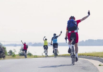
By power of sail, motor or a paddle, the Rideau Canal and its associated Tay Canal are an amazing boating destination. Having 45 locks at 27 lockstations, the Canal is chain of beautiful lakes running 202 km from Lake Ontario in Kingston to the Ottawa River in Ottawa, with a 10KM side trip to the Town of Perth. It is is a mecca for boaters and is well marked with buoys, making it very easy to navigate and offers un-paralleled viewing of scenery and wildlife, and an introduction to the area’s late 18th century history. Planning on touring the Rideau Corridor could not be more easy or fun.
Nautical Chart Information:
Two 1:20,000 scale hydrographic charts (canal navigation maps) cover the Rideau – Chart 1512 covers Ottawa to Smiths Falls and Chart 1513 covers Smiths Falls to Kingston. These charts may be purchased at various lockstations, the Rideau Canal headquarters, or from the Friends of the Rideau (visit their website, or phone 1-613-283-5810).
National Topographic Series maps covering the Rideau Waterway at the 1:50,000 scale are 31C8 (Gananoque), 31C9 (Westport), 31C16 (Perth), 31B13 (Merrickville), 31G4 (Kemptville), and 31G5 (Ottawa). To find a map dealer in your area, visit their website, or phone 1-800-465-6277.
Boat Launches along the Rideau:
Name
Location
Description
Rideau Acres Campground
10 km north of Kingston on Cunningham Road. 2 km north of Hwy 401. On Colonel By Lake
Good launch, steel grating over gravel. Accommodates boats up to 25 feet. Dock, parking and picnic tables available. Launch fee: $5
Bill Hughes’ Ramp
13 km north of Kingston on Hughes Road. 5 km north of Hwy. 401. Follow pavement to gravel, past farm to the ramp (about 4 km). On River Styx
Gravel ramp. Accommodates fishing boats up to about 18 feet. No dock. Parking and camping available. Launch fee: $10
Dog Lake, Gilmour Point
33 km north of Kingston on Hwy 15 – then about 18 km west of Hwy 15 on Burnt Hills Rd. to Battersea. About 1 km east on Wellington Road to ramp. On Dog Lake
Steel grate on gravel. Dock. Parking available (no overnight parking). Accommodates boats up to 20 ft. Launch fee: free
Melody Lodge and Marina
33 km north of Kingston on Hwy 15 – then 10 km west of Hwy 15 on Burnt Hills Rd., past Carrying Place to marina. On Cranberry Lake
Paved ramp. Fairly steep. Dock. Parking. Picnic area. Accommodates boats up to 26 ft. Launch fee: $5
Henry Knapps Campground
33 km north of Kingston on Hwy 15 – then 2 km west of Hwy 15 on Burnt Hills Rd., past Brass Point Bridge to campground. On Cranberry Lake
Gravel ramp with paved approach. Dock. Accommodates boats up to 24 ft. Parking available, $2 fee. Launch fee: $3
Seeleys Bay
34 km north of Kingston on Hwy 15. Take Main St off Hwy 15 (west) then left onto Bay St. If coming south, turn west onto Mill Street to where it meets Bay St. On Cranberry Lake
Good paved launch with docks and ample parking. Supplies and amenities in village. Accommodates boats up to 28 ft. Launch fee: free
Shangri La
44 km north of Kingston, 3 km west on Jones Falls Road. On Whitefish Lake
Gravel launch. Dock. Parking, $4 fee. Fuel, ice & phones. Accommodates boats up to 36 ft. Launch fee $6
Sand Lake Marine
44 km north of Kingston, 5 km west on Jones Falls Road, turn right (north) onto Sand Lake Road. Next left is Glover Road, about 1 km to left at Hugh’s Road, then 1 km to Marina. On Sand Lake
Gravel launch. Dock. Parking, ice, fuel, repairs. Accommodates boats up to 26 ft. Launch fee $5
Sand Lake Road
44 km north of Kingston, 5 km west on Jones Falls Road, turn right (north) onto Sand Lake Road. Next left is Glover Road. Continue to end. On Sand Lake
Small paved to gravel launch. Dock. Limited parking. Accommodates boats up to 20 ft. Launch fee: free
Battams Road
52 km north of Kingston, on Hwy 15 to Elgin. Turn left (west) onto Davis Lock Road for 1 km, then left on Bush Road for 0.5 km, the right onto Battams Rd. Continue to end of road (2 km). On Sand Lake
Small gravel ramp. No dock. Limited parking. Accommodates boats up to 20 ft. Launch fee: free
Franklin’s Marina
Chaffeys Lock Road – 8 km west of Hwy 15. On Opinicon Lake
Good ramp. Parking for car and trailer, $1 fee. Accommodates boats up to 30 ft. Launch fee: $5
Iron Bridge Lane (Chaffeys – Indian Lake)
Chaffeys Lock Road – 8.5 km west of Hwy 15. Turn right just after Brown’s Marina. On Indian Lake
Paved ramp. Limited roadside parking (or see owner of Simmons’ Lodge for parking). Accommodates boats up to 25 ft. Launch fee: free (donation box available for donations)
Opinicon Hotel
Chaffeys Lock Road – 9 km west of Hwy 15. On Opinicon Lake.
Paved ramp up to water then gravel & sand. Accommodates boats up to 24 ft. Free for hotel guests. $6.50 fee for non hotel guests
Indian Lake Marina
Marina Road – 7 km west of Hwy 15 on Chaffeys Lock Road, turn right on Marina Road and go 1 km to Indian Lake Marina. On Indian Lake
Paved ramp. Dock. Parking available. Accommodates boats up to 35 ft. Launch fee: $5
Newboro
59 km north of Kingston on Hwy 15. Turn left (west) at Crosby onto Cty. Rd. 42 and go 5.5 km to Newboro. Turn left onto Lock Road to village maintained launch ramp and parking lot. On Newboro Lake.
Paved ramp. Parking $1 cars/trucks; $1 trailer (must be detached from vehicle). Accommodates boats up to 35 ft. Launch fee $2.60 ($5.15 for boats over 20′)
Forresters Landing Drive
10 km west of Hwy 15 on Cty. Rd. 42, just before Westport. On Upper Rideau Lake
Gravel ramp and dock maintained by the Rideau Valley Conservation Authority. Roadway parking. Accommodates boats up to 25 ft. Launch fee: free
Westport (“The Cove Boat Launch”)
15 km west of Hwy 15 on Hwy 42. At bottom end of Bedford Street (turn right onto Rideau Street, continue around to Main Street, then right at The Cove Restaurant on Bedford Street.) On Upper Rideau Lake
Paved ramp and sheltered dock. Limited roadside parking. Accommodates boats up to 28 ft. Launch fee: free
Crosby/Big Rideau Lake Road
Off Hwy 15, on Cty. Rd. 42, take 1st right onto Narrows Lock Road, 3 km to McCann Rd. Continue 2.5 km to Big Rideau Lake Road, turn left (west) and drive 1.5 km to ramp. On Big Rideau Lake (Hudson Bay).
Steel grated launch ramp. Dock. Limited roadside parking. Accommodates boats up to 20 ft Launch fee: free
Murphys Point Provincial Park
Off Hwy 15, on Cty. Rd. 2, take 1st right onto Narrows Lock Road. Follow road about 12 km, across Narrows Lock to County Rd. 21, into Murphys Point Provincial Park. On Big Rideau Lake.
Gravel ramp. Dock. Good parking, toilet, picnic tables. Day use fee $8.50 (includes parking)
Portland
On Hwy 15, 66 km north of Kingston. Turn left onto Colborne Street, the left (west) on St. Mary’s to ramp. On Big Rideau Lake
Paved approach ramp, steel grate over gravel. Parking on street. Full services in village. Also pay ramps at Lens Cove Marina or Bayview Yacht Harbour Marina. Accommodates boats up to 30 ft. Launch fee: free
Portland
On Hwy 15, 1.5 km north of Portland. On Big Rideau Lake
Gravel ramp. No dock. Good parking, toilet, picnic tables, lookout area. Accommodates boats up to 18 ft. Launch fee: free
Rideau Ferry Yacht Club CA
Turn left (north) at Lombardy onto Rideau Ferry Road and continue 6 km to village (17 km N of Portland, 83 km N of Kingston, 11 km S of Smiths Falls.) Turn right onto Yacht Club Road and go 1 km to Rideau Ferry Yacht Club Conservation Area. On Lower Rideau Lake
Concrete ramp. Parking. Toilets. Picnic Tables. Accommodates boats up to 18 ft. Launch fee: $5/day/vehicle; $2/person/walk in, bikes, boats and etc./day
Rideau Ferry Harbour (marina)
1 km north of Rideau Ferry, turn left (west) onto Coutts Bay Road, 2 km to Rideau Ferry Harbour. On Big Rideau Lake
Wide dirt launch, dock and lift for larger boats. Parking $2. Accommodates boats up to 40 ft. Launch fee: $6 (if putting boat in yourself); $25 (if require tractor lift)
Lower Beveridges Lockstation
1 km north of Rideau Ferry, turn right (east) onto Port Elmsley Road (County Road 18), and go 3 km and turn right, just past bridge to Beveridges Lock station. On Lower Rideau Lake
Paved ramp. Cement dock. Parking, toilet, picnic tables. Accommodates boats up to 30 ft. Launch fee: $8.40/day – $94.10/season
Poonamalie Road (Poonamalie Lock)
91 km north of Kingston, 7.5 km north of Lombardy, turn left (north) onto Poonamalie Road, continue 2 km on dirt road. On Lower Rideau Lake/Rideau River
Gravel ramp. No dock. Parking. Accommodates boats up to 24 ft. during low water season (mid to late summer) & 40 ft. during high water season (spring). Launch fee: $8.40/day – $94.10/season
Smiths Falls (Detached Lock)
94 km north of Kingston. Turn left onto Abbott St., cross bridge, then turn left at the Parks Canada Detached Lock. On Rideau River
Paved ramp. Cement dock. Picnic tables. Parking ($3 day fee). Accommodates boats up to 20ft. Launch fee: $8.40/day – $94.10/season
Edmonds Lock Lane (Edmonds Lock)
Take County Rd 17 (Jasper Road) from Smiths Falls to Edmonds Lock. On Rideau River
Paved ramp. No dock. Parking ($3 fee – use upper parking lot). Accommodates boats up to 30 ft. Launch fee: $8.40/day – $94.10/season
Riverside Camp
10 km east of Smiths Falls on Hwy.43 to 1st entrance to River Road, continue another 5 km to 2nd entrance. The from 2nd entrance, travel 3 km to Riverside Camp (between Kilmarnock Lock and upper Merrickville Lock. On Rideau River
Gravel/Dirt ramp. Parking. Toilets. Accommodates boats up to 16 ft. Launch fee: free if staying at park; $5 if not staying at park
Montague Township
From Riverside Camp, continue past to Boat Launch Road. On Rideau River
Gravel ramp. Narrow dock. Limited parking. Accommodates boats up to 16 ft. Launch fee: free
Lions Campground, Merrickville
Turn west (towards Blockhouse) at flashing light in Merrickville onto Main Street. Go past Blockhouse parking then turn right at Lions Campground. On Rideau River (upstream of Merrickville locks)
Good paved ramp. No dock at ramp. Parking. Accommodates boats up to 26 ft. Launch fee $3.50
Rideau River Provincial Park
19 km north of Merrickville, turn left (west) onto County Rd 44, 5.5 km to Rideau River Provincial Park. On Rideau River
Paved ramp to shallow gravel. Cement pier, parking, toilets. Accommodates boats up to 23 ft. Launch fee: $8.50
Pirates Cove Marina
From Kemptville, head east on Hwy 43 then turn north on County Road 19 (River Road) for 5 km. Turn left (west) opposite Flynn Rod into Pirates Cove Marina. On Rideau River
Paved ramp. Good dock. Washrooms. Full marina facilities. Parking. Accommodates boats up to 50 ft. Launch fee $10
W.A. Taylor Conservation Area
On River Road (Cty Rd. 19), about 23 km south of Ottawa. Turn left (west) opposite junction of Road 114 to Osgoode, and go into W.A. Taylor Conservation Area. On Rideau River
Paved ramp. Good dock. Toilets. Picnic tables. Parking. Accommodates boats up to 20 ft. Launch fee: $5/day, $35/season
Kars
21 km south of Ottawa on Carleton Road #6 (aka Roger Stevens). Take Rideauu Valley Drive to Kars. Turn left at Wellington Street to small craft ramp. On Rideau River
Good cement ramp. Pier. Walk 0.5 km to Kars recreation area for parking. Accommodates boats up to ?. Launch fee: free
Long Island Marina
2 km north on Commodore Lane in Kars. On Rideau River
Gravel ramp. Dock. Accommodates boats up to 35 ft. Launch fee $10 (includes parking)
Gloucester Eccolands Park
11 km north of Manotick, turn left opposite Environmental Technology Centre. On Rideau River
Wide paved ramp. Floating docks. Toilet. Kids playground. Parking. Accommodates boats up to ?? (prob. at least 30 ft.) Launch fee: free
Hogs Back
off of Hogs Back Road. On Rideau River
Concrete ramp. Accommodates boats up to 26 feet. Launch fee: $8.40/day – $94.10/season
Dows Lake at the Pavilion
off Prince of Wales Drive, turn right at Preston. On Dows Lake
Wide corrugated cement ramp. Parking ($5). Accommodates boats up to 65 ft. Launch Fee $10